The idea of Caminos Naturales was born in 1993. Since then, very diverse routes for walking and cycling have been incorporated into the network. Many of them were already GR (Great Route) trails marked with red and white paint marks, others are Vías Verdes (old railway lines), there are also newly created ones. They follow coastal paths, mountain paths, rural paths, forest tracks, neighborhood paths, hydraulic public domain paths and even, as I say, old train lines.
In total, the Ministry of Agriculture, Fisheries and Food has invested 257 million euros since the beginning of the program. The idea is that the Ministry finances the works to create the path and the promoting entities (City Councils, Provincial Councils, Autonomous Communities…) are in charge of its maintenance. This is not a trivial question, because experience tells us that the most complicated part of these infrastructures, designed for the enjoyment of lovers of the open air, but also for the structuring and help for the development of large territories of that Empty Spain, is not to make them but keep them operational over time. Recent history is full of well-intentioned cases in which a public administration spends millions of euros to signpost and prepare a path and a year later it is unusable because signs have disappeared, the bush eats up the path and the rude people on duty have vandalized the installations.
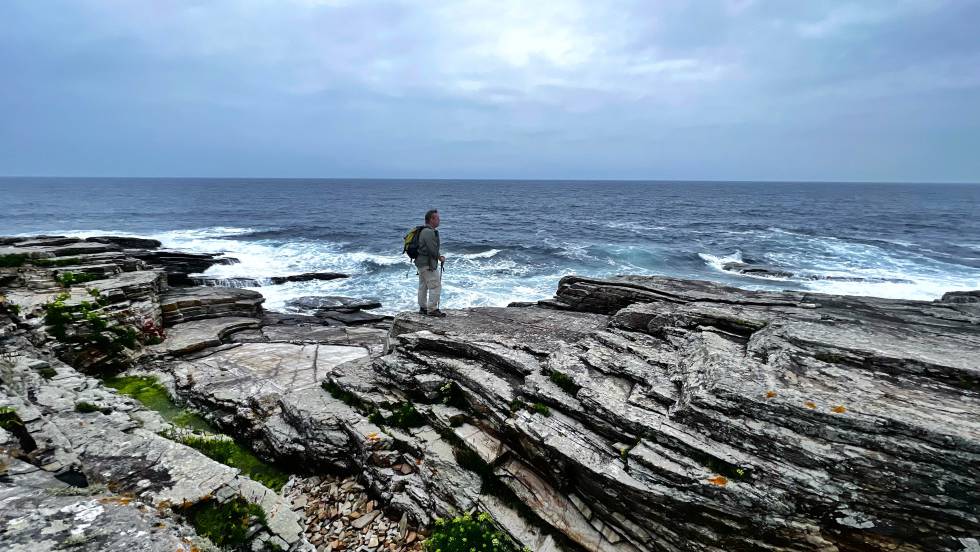
I know many Nature Trails. In fact, right now I am repeating the Cantabrian Route, one of the most beautiful, which begins in Ribadeo and goes along the entire coast of Lugo and A Coruña to the gates of Cabo Ortegal. I did it a while ago by bike and now I’m repeating it on foot, although only a few sections. Like all the others I know, it is very well signposted and the layout takes advantage of existing paths, paths and tracks, avoiding asphalt whenever possible.
These are six Nature Trails that I know and that I recommend you to do on these vacations. If you want to know more, you have all the information, maps, altitude profiles, description and services of each of the 130 routes on the website of Natural Path of the Ministry of Agriculture, Fisheries and Food.
Cantabrian Route Nature Trail (150 kilometres)
It starts in Ribadeo, on the border between Galicia and Asturias and runs through the entire Mariña Lucense and part of the Rías Altas. A beautiful and quite wild path that almost always goes along the sea (except in the San Cibrao area, where it must go around the large industrial port) through some solitary and surprising landscapes. At the moment it ends in Ladrido, a small village on the Ortigueira estuary. There are plans to take it to nearby Cabo Ortegal
Cumbres de La Gomera Nature Trail (44.5 kilometres)
Six of the eight Canary Islands have signposted Nature Trails. I have done several, but if I have to choose one, I would choose this one, which crosses the entire island of La Gomera through the Garajonay National Park. It is a hard and demanding route, with slopes of more than a thousand meters in a single stage (La Gomera is a pure ravine), but of extreme beauty.
Oil Greenway (128 kilometres)
It coincides with one of the most famous and busy Vías Verdes in Andalusia, which takes advantage of the platform of the old 19th century railway line that connected Linares (Jaén) with Puente Genil (Córdoba). It starts in the city of Jaén and ends in Puente Genil. As its name suggests, it passes through some of the best olive-growing landscapes in both provinces. It is equipped with many services for the traveler. A perfect route to do by bike.
Herding Path (485 km)
It coincides with the GR-282 and follows the layout of old routes of shepherds who wandered through the mountains that surround the great plain of Alava. A very long circular route but loaded with historical and ethnographic meaning that brings you closer to mountain landscapes and pastures impossible to discover in any other way. It has 19 stages and passes through the territories of Álava, Vizcaya, Guipúzcoa, Burgos and Navarra.
Camí de Cavalls (185 kilometres)
A path along the entire coast of Menorca full of history and symbolism. The Camí de Cavalls or Camino de Caballos was laid out throughout the 18th and 19th centuries to facilitate the transit of cavalry between the different defensive and customs buildings that extended along the entire Menorcan coast. It passes through the coastline of the eight coastal municipalities of the island and through areas of high natural and scenic interest, such as the Albufera des Grau, Illa d’en Colom and Cap de Favàritx natural parks.
Northwest Greenway Nature Trail (80 kilometres)
It starts in Murcia and runs parallel to the Segura river for the first few kilometers to then turn towards the Northwest region through some of the most spectacular desert landscapes of the badlands of the Mula river basin. It follows the route of the old Murcia-Caravaca de la Cruz railway, which stopped working in 1971.
#Natural #Paths #discover #Spain #foot #bike


