EL PAÍS offers the América Futura section openly for its daily and global information contribution on sustainable development. If you want to support our journalism, subscribe here.
Like those pre-Hispanic peoples who settled in this region of Veracruz thousands of years ago, the residents of Mano Perdida, a rural community that appears among the wetlands of the Alvarado lagoon system, are governed by a water calendar. In it, two seasons mark a way of life linked to the cycles of nature. The rainy season, which usually arrives at the end of September, with the turbulent and greenish currents, when the roads that interconnect the municipalities are flooded. “And the dry season, which begins in April or May, in the months when we consume the most water and get the most profits from fishing,” says Felipe Ramírez, 72 years old. The gaze of the old man, who protects himself from the sun with a cowboy hat, is directed to the circular map that is displayed on the table where the fishing cooperative that he presides meets.
In the center of the map, different drawings are outlined that represent community knowledge according to the month: a thermometer in red to indicate the hottest days; a blue drop when the water is cleaner; another black to warn that the water from the taps comes out dirtier; the silhouette of a well to remember that every three months the community's water tank must be cleaned with chlorine. Information that the group of researchers that make up the Water Reserves Monitoring Network (Redmora) is transforming into socio-environmental data. The objective of this scientific project is to measure in a technical and very precise way the conditions of the ecosystems in which the inhabitants of Bajo Papaloapan live, plains where the Olmecs and other Gulf cultures settled more than a century ago. In this precise place, the Jarocha tradition was later developed, “the set of sociocultural aspects resulting from the mixture of coexistence between indigenous societies, Spanish, African roots and other migratory influences that created this cultural wealth so typical of the Veracruz tropics,” explains Xochitl. by A. León Estrada, anthropologist and archaeologist from Xalapa.
This basin, which originates between the tropical jungles and temperate forests of Oaxaca and flows into the central-southern region of the State of Veracruz, is the second most important in Mexico. “Although the area has been little explored compared to others, in it Multiple archaeological finds have been discovered, pre-Hispanic vestiges that remain under the undergrowth, as well as obsidian utensils for scaling fish, among other pieces of immense historical value that tell how the ancient inhabitants of the mangroves already subsisted thanks to the aquatic resources of the region. “explains León Estrada, an anthropologist and archaeologist from Veracruz, member of the group of experts that analyzes the effects of pollution on the ecosystems of Bajo Papaloapan and on riverine fishing.
This activity constitutes the main means of subsistence in Mano Perdida, a small piece of land with just over 200 inhabitants, where the property is mostly ejidal and which is accessed by an asphalt road connected to the highway that winds parallel to the Papaloapan River. place of butterflies in Nahuatl. The quality of the water that bathes the ecosystems is being affected by the pollution caused by sugar cane plantations around the communities, a million-dollar company that devours more land from the natural landscape every day.
According to Patricia Moreno-Casasola, researcher at the Institute of Ecology (Inecol), this industry is causing fisheries to lose habitat and putting people's health at risk. “The runoff from herbicides and other chemicals used in sugarcane cultivation is transported from the Acula River to the Alvarado lagoon and does terrible ecological damage, not only in the surface waters, but also filters into the groundwater,” he says. the environmentalist. In addition to the alcohol products that are made from its cultivation, sugarcane is planted mainly to export millions of tons of fructose abroad. The United States is its main buyer.
To eradicate pests, such as the screwworm, sugarcane farmers use furadan, one of the most toxic pesticides that exists. In some water samples, in addition, “atrazine, a very dangerous chemical for the environment and aquatic organisms, has been found,” highlights the RedMora scientist. In the calendar prepared by residents and scientists, the months in which the effects are most serious are observed. “The harvest season, the beginning of the harvest, begins in December, but it is in October when the mills wash and the water arrives dirtier, due to the rains and the tides,” says Beatriz Zamudio, a member of the fisheries cooperative. and to whom his father instilled the trade in him from the age of 6.
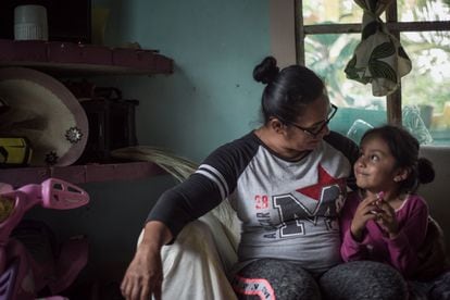
“He took me on his boat since I was a little girl,” says the woman, mother of two girls and grandmother of one girl. The fisherwoman supports the entire family with what she earns every day on her boat. “It's what I always did,” says Zamudio, who at the age of 10 also learned to milk cows on a family ranch. “My dad instilled in me from a very young age the importance of being independent, of not needing a man to survive. That's what he told me and I always followed his advice. I only spend to invest in material, to make my own traps: with the bugles you catch the shrimp, with the pots, the crab,” he explains, pointing to the fishing nets that hang at the entrance of his home.
Zamudio's house stands on an islet of land along the canals like water tongues that intertwine the lagoons. A little house where herons, pelicans, cranes appear every day… the biodiversity that surrounds the small corral at the edge of the water where the fisherwoman keeps the breeding animals: chickens, ducks, two pigs. “From the sale of the first pig, I bought my daughters' uniforms and was able to pay for their school registration. I didn't have it, that's why I know that education is very important, and I invest in it so that they study and don't have to work as hard as I do,” says Zamudio proudly, while driving the engine of her boat among the mangroves.

While so many territories in Mexico suffer serious droughts, in this enclave of Veracruz there is an abundance of water, so much so that during the stormy season the latent danger of flooding threatens. “The detail is that the water is not clean and we have to buy it in jugs,” laments the fisherwoman. The only well built in Mano Perdida is dry and, like the rest of the communities settled around the wetlands, it does not have access to quality water. Residents have to acquire it from purifiers in distant cities. “We use a lot of water to drink and cook and, sometimes, we go several days in a row without it because they take a long time to bring us the gallons. We only use the one with the tanks to bathe and wash, but it is very dirty,” says the woman.
In addition to the contamination due to the abuse of fertilizers and herbicides used in the planting of sugarcane and other crops, in Bajo Papaloapan other problems are causing the daily life of its populations to collapse, such as those derived from the drastic changes in land use that are taking place. can be seen in their landscapes. In them a mosaic is repeated: mangrove lagoon, tule, sapotes, a small pond and pastures, extensions of native vegetation altered by uncontrolled livestock exploitation. This Veracruz region has one of the most serious deforestation rates of all the pilot sites of the National Commission for the Knowledge and Use of Biodiversity (Conabio). As in so many other places in Latin America, the Alvarado wetlands are mimicked in flooded grasslands for cattle grazing, a sector that in the 1970s began to transform lake surfaces into pastures. “And in which many chemicals are also used, such as tick killers,” says Moreno-Casasola. Deforestation does not only occur near lagoons. “One of the problems that worries us the most is silting,” says the environmentalist, referring to the sediments caused by the erosion of soils that suffered the removal of their forest layer.
Throughout the year, the tributary that bathes this lagoon complex travels from the upper area of the basin, the mountains of Oaxaca, and drags in its path pollutants that accumulate on the Veracruz coast. But, as the scientist explains, “with the arrival of cold, rain and north winds in November, the waters run rough and black due to silting, a phenomenon that reduces the capture of shrimp, crab and mojarra.”

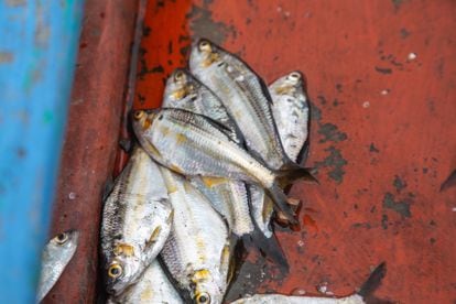
They live on these fish products all year round in Mano Perdida. “There are others who have their temporality. From June to August is bass spawning, for example. And the naca harvest has just finished,” explains Ramírez. The capture of this unique fish, which uses its eggs, “is a custom that has been maintained since pre-Hispanic times, among other traditions that relate how various cultural groups used the river flows to trade fishery products from the Costa del Sol. Gulf to the Central Altiplano,” says León Estrada.
The unique biocultural ecosystem of Bajo Papaloapan, its biodiversity and balance, are being increasingly affected by deforestation, drastic changes in land use, abuse of fertilizers and herbicides used in sugarcane planting, and uncontrolled livestock exploitation. and the disastrous quality of water that puts the health of the inhabitants of Mano Pérdida at risk. The community now fights to recover the symbiotic human-nature relationship to the sound of the water flows created so long ago in these plains.
#Lack #access #clean #water #threatens #Bajo #Papaloapan #cradle #Jarocha #culture
