EL PAÍS offers the América Futura section openly for its daily and global information contribution on sustainable development. If you want to support our journalism, subscribe here.
Last Wednesday, starting at four in the afternoon, it had to rain in Tijuana. That was what Civil Protection had foreseen. Much sooner, after ten in the morning, the sky darkened, the lightning began and the water was released with force. It lasted just over an hour. Enough to fill WhatsApp and social networks with messages and images of hurricane-force winds that blew up umbrellas on the terraces of some bars, caused fires due to electrical incidents, falling poles and fences, and a major blackout that affected many parts of the city, with broken traffic lights and dark houses. Even the Municipal Palace, headquarters of the city council, had to suspend activities due to lack of light.
Later, authorities reported that this blackout left more than 160,000 people without electricity along the Baja California coast: in Tijuana, Rosarito, Ensenada and San Quintín. Due to the rains and atypical winds of more than 45 kilometers per hour. To compare them: the mildest hurricanes—category one—arrive with winds of 119 km/h and above, according to the Mexican Governmentusually generate “slight effects.”
During the beginning of the chaos, Mayor Montserrat Caballero appeared on Facebook Live and explained the situation. She asked citizens to stay home if they did not need to go out. She also reported that there would be no classes in the schools in the afternoon because more rain was forecast. That morning of November 15, according to Civil Protection, between 1.5 and 6 millimeters of rain were recorded in Tijuana. The national government data for this municipality establishes that the rainfall threshold ⎼ the limit for problems to begin ⎼ is 60mm. That Wednesday morning it rained ten times less, but there were many problems.
It is not new. In the last winter season, between the end of 2022 and the beginning of 2023, there were significant floods, ten landslides were activated, two minors died, several houses had to be evacuated and dozens of families were affected. This led the authorities to declare a State of Emergency due to geological and hydrometeorological risks.
Why does chaos break out in Tijuana every time it rains? According to experts, there are three main causes that trigger many others: the relief in this area favors floods and landslides; The lack of rainwater infrastructure and the excess of garbage in the streets makes everything clog more easily; and the unequal and uncontrolled urban growth ⎼ which encourages corruption ⎼, enhances the disaster and makes possible remedies difficult. These are solutions that are urgently needed because climate change is aggravating the situation. As Miguel Ángel Ceballos, director of Civil Protection of Tijuana, says, the rains previously “did not occur in November, it was from January onwards,” but in recent years they have come earlier. Furthermore, “now there is also the mexican monsoonin June and July”, a phenomenon that he defines as new that causes an increase in precipitation in the northwest of the country from June to September.
Resist and recover
During the morning of November 15, some of the most striking images came from Zona Río and the Hippodrome, middle and upper class areas. Nature does not understand money; What makes the difference is the ability to resist destruction and recover afterwards. It is told by Dr. Juan Manuel Rodríguez Esteves, researcher at the Colegio de la Frontera Norte (Colef) and expert in disasters associated with water. He gives the example of the Chapultepec neighborhood, one of the most exclusive in the city: “Part of it is at risk, in a hillside area. “They have had problems with floods, but they are less vulnerable because they have more financial resources, more political resources, etc., and they rebuild quickly.”
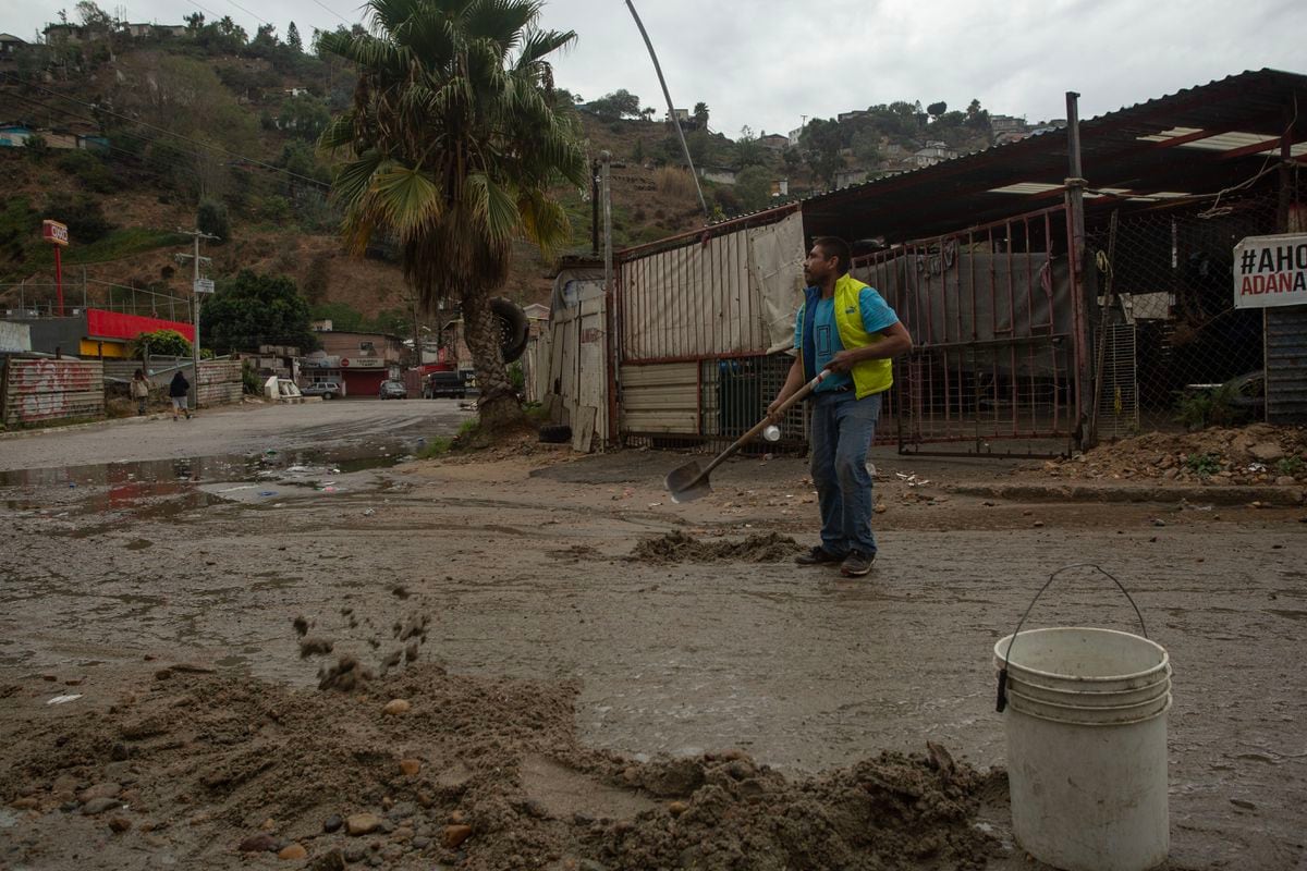
Miles away from those luxury houses, in the same city, although it seems different, José Guzmán Palomares sees the rain and goes out to work. “José, alias the Turtle,” he points out, smiling, “because he was very fat before.” And while he introduces himself, he moves the shovel to remove the mud and stones that have piled up in the middle of the street. This makes it easier for cars to pass.
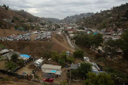
Where the Tortuga steps, the ground is asphalt. Other parts are unpaved. That asphalt is one of the few connections with the rest of the city of Tijuana. One of the few exits is a one-way lane for all the people spread across more than 13,000 homes along the almost 12 square kilometers that make up the hills, slopes and gorge of the Los Laureles canyon. Many of these homes are irregular, built with very vulnerable materials, some without drinking water or drainage systems.
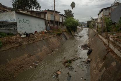
That is one of the condemnations of this city: its cannons. Dr. Rodríguez, from Colef, explains it clearly: “This means that when there is rain, the water runs quickly. “There is little time for people to react.” This is what happens in this corner of the Los Laureles canyon. “It’s not so much the rain, but rather that a lot of garbage comes down from up there, from the hill,” says Concepción, standing in front of her tire shop, a few meters from where José cleans the street. “This floods and the water reaches halfway up my leg.” The key, according to her, is that the collection truck only comes by on Tuesdays, and since people work, they leave their waste the day before and the dogs destroy it. “The garbage people just grab the bags that are there, the rest stays there and when it rains it runs off, and all this is filled with garbage. That’s why it is covered. There is drainage but it is already old,” Concepción complains.
The stormwater infrastructure throughout the town is insufficient and overflows quickly. Ceballos, the director of Civil Protection, admits that “the city does not have much storm drainage, what we have most of is sand traps.” Specifically, 37 sand traps in the lower parts of the canyons, which filter rainwater and separate solid materials so that the liquid flows more easily. Architect Rodolfo Argote, former director of the Tijuana Metropolitan Planning Institute, adds a historical nuance: “The infrastructure that was built initially did not foresee so much growth. It has been replaced in some parts, but not in others, it is already obsolete.”

Mapped risk
Here the climate is semi-arid, it does not usually rain much, but the surface where this city sits is full of canyons, hills, streams, and its soil is not consolidated, it moves easily. That combination means that when there is rainfall, everything wants to go towards the Tijuana River. In the words of the director of Civil Protection, the municipality receives on average “1 inch or 1.5 inches [entre 25 y 38 mm] in 24 or 36 hours of storm.” The problem is when that amount of water falls in much less time.
The problem is well represented in risk atlases that Civil Protection updated in 2019. There, all areas prone to flooding have been defined in detail, where there are streams and where there have been historical floods, and all unstable slopes with potential for landslides. And according to Ceballos, his body will “receive an augmented reality table, to be able to visualize how the water will behave when it reaches the canyons.” These Civil Protection maps define the Los Laureles canyon as the epicenter of multiple risks, both flooding and landslides.
“When it rains in Tijuana, corruption surfaces in its streets”
Dr. Juan Manuel Rodríguez, the Colef researcher, is categorical when defining the problem: “Natural disasters do not exist. It is not natural that we have built hotels facing the sea, or that people live on streams because there are no other options to build their homes. So, let’s call it a social disaster.”
The Civil Protection risk maps are also available from the Tijuana Government area that grants building permits. Even so, “it would have to be analyzed case by case, but from a bird’s eye view it does not seem that it is being respected, because you see constructions in risk areas,” says Rodríguez. The consequences of this appetite for building are explained in his book Of rains and disasters: A model to manage risk in Tijuana: “The rapid process of urbanization translates into increased deforestation, which implies changes in rainfall discharges, erosion and sedimentation,” he points out.
In another, slightly older investigation, from 1998, Víctor Alejandro Espinoza is more forceful: “The voracity of the fractionators had no limits, not caring about the consequences of the destruction of natural channels and diversion of streams. When it rains in Tijuana, corruption surfaces in its streets.” And he blames the disaster on a type of development that “has opted for easy profit.”
A third investigation from 2018, by Colef, adds numbers: “More than 10% of the population (more than 153,000 inhabitants) live in areas of high vulnerability to floods, and another 18% (277,000 inhabitants) in areas of medium vulnerability. -high”.
If the map of vulnerabilities had been superimposed over Tijuana, like a hologram, on the morning of November 15, surely one of those numbers would have floated over the head of José the Tortuga, in a corner of the Los Laureles canyon while he moved the shovel and held a small cardboard cup so that the cars could tip him something for cleaning the street. “Since I have kidney disease, I have a hernia and other things, well I don’t have a job.” That’s why when rivers of mud, garbage and water are created, José goes out into the street shovel in hand to clean up the destruction with his fluorescent yellow Puma vest so that he can be seen well. It is a job with which he can earn 600 or 700 pesos (35 or 40 dollars) a day. “But others arrive who are also doing the heel [trabajando] and well, there’s no way to tell them, hey, go away. No, there is something for everyone.”
#voracious #urbanism #condemns #Tijuana #disaster #rains