If the soldiers of the Roman general Tenth June Brutus had come across the river Limia 22 centuries later, they would have crossed it without getting the soles of their sandals wet. Probably they would not have even realized that they were before their dreaded Flumen Oblivioniseither Lethes, that mythological stream of water with which the Limia was identified when it arrived in Galicia and on which innumerable warnings from classical authors weighed. The river was a terrible barrier in the Roman conquest upon reaching the current province of Ourense, because it was known that whoever crossed it would lose his memory. Until, according to what is transmitted by word of mouth in this place where Galicia is transformed —almost without realizing it— into Portugal, the brave leader of the ranks decided to cross it. From the other shore, the general called his soldiers by his name to show that the amnesia thing was a hoax. Today, as the reports sent by scientists from the Galician Natural History Society (SGHN) to the Ministry for Ecological Transition say, the River of Forgetfulness has become “the forgotten river”: squeezed dry from its head by catchments for irrigation and macro-farms, until putting in check “12 taxa of flora and fauna threatened at regional, Spanish and European level”.
In addition to frogs, toads, fish and birds in a vulnerable situation or plant species such as a fern in danger of extinction in Galicia, the greatest risk hangs over a rare blue thistle typical of wetlands in northwestern Iberia and France. Is he Eryngium viviparum, an amphibious umbelliferous plant that without water does not survive that average of 83 frosts that are recorded per year in the area. Here, in this exhausted territory saturated with nitrates due to decades of unbridled agricultural exploitation, according to the SGHN “96% of the world’s population” of the stickleback is concentrated. Eryngium viviparum.
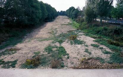
After years of complaints before which the different Administrations with responsibilities in the river never got involved, the environmental defense group brings to light the devastating data provided by the Automatic Hydrological Information System of the Ponte Liñares river station, which manages the Miño-Sil-Limia Hydrographic Confederation. According to these official records of the basin organization dependent on the ministry, in the last 10 years the minimum ecological flow was breached one out of every three days, and one out of every nine not even half of this essential water limit was reached without which fauna and flora do not survive. This extreme situation occurred repeatedly for more than three months in a row in 2013, 2014, 2016, 2019 and 2020, and in 2017 the circulating flow plummeted to a tenth of the minimum ecological threshold.
The data “indicate a serious and systematic breach of the Hydrological Plan of the Miño-Sil Hydrographic Demarcation in the upper Limia basin”, denounces the SGHN, in such a way that “in the summers and autumns of every year and in a winter of every three is in a situation of collapse due to the overexploitation of surface and groundwater bodies.” Together with the written report and the charts prepared by the group, photos of the completely dry riverbed and the delusional illegal pumping systems bailing out the river in broad daylight have been sent to the Cabinet of the Minister for Ecological Transition, Teresa Ribera. with complete impunity.
The tubes connected to these motors end up reaching onion and potato plantations, flagship products of the A Limia region, whose fields are fertilized with tons of manure produced by the farms (there are more than 350 pigs and chickens in the region). Scientific hypotheses point to low nitrate contamination through the emaciated river and its tributaries to the As Conchas reservoir, which records serious episodes of cyanobacteria every year due to eutrophication of the waters. In this swamp built by Fenosa in 1948, the Roman camp of Aquis Querquennis was buried, which emerges seasonally, and for a longer time, due to the drought.
Information is the first tool against climate change. Subscribe to it.
subscribe
Every year some 120,000 tons of the famous A Limia potato are harvested on a cultivated area of more than 3,500 hectares. The soil scientist from the CSIC (Higher Council for Scientific Research) Serafín González, president of the SGHN, explains that “every kilo of potatoes needs 86 liters of water”. According to the data of the Hydrographic Confederation (CHMS), which in a 2020 report recognizes that the Limia system reaches states of “emergency, probably due to problems of structural scarcity”, the moments of “normality” are as frequent as those of “pre-alert”, more than one in three months. The “alert” occurs one out of every five months and the “emergency” occurs one out of every nine every year.

The panorama has been repeated since the end of the 1990s, as the chairmanship of the CHMS admitted in 2012, but the increase in consumption cannot be linked to the industry, which hardly exists, nor to human supply, with a population in decline sustained since 1950. In contrast to this, according to the SGHN, the stocking rate has doubled since 1999 (from 42,000 to 85,000 UGM or large livestock units). At the same time, irrigation has experienced a “huge increase”, says the group that has studied the natural environment since 1973: many have official permission granted or in process, backed by a “strategic plan for the agricultural sector” that “the Xunta de Galicia intends to finance with the Next Generation funds”. “The peak consumption, basically to grow potatoes, is 15.3 million liters/hour,” calculates the report presented to the ministry. “Between the legal concessions and those that want to be legalized” only in this region the annual consumption is slightly less than the volume of water for human supply in the entire province of Ourense.
“The chronic hydrological collapse at the head of the Limia system is especially worrying due to its serious effects on the values of the natural spaces of its basin, protected by six protection figures,” recalls the SGHN. In the region, the supposed environmental shields of ZEPA (Special Protection Area for Birds, whose sustainable development plan has been dormant without being approved by the Xunta for more than 11 years), ZEC (Special Conservation Area), and two reserves coincide. of the Biosphere, the Allariz area and the cross-border Gerês-Xuréswhich also includes a natural park on the Spanish side and a national park on the Portuguese side.
In the landscape of this dying river, a project announced by the Minister for Ecological Transition was framed, the partial restoration of the Laguna de Antela, announced on Wetlands Day 2021. Here, among other natural values, the entire population Galician European Lapwing (vanellus vanellus) and is the habitat of other birds (such as the common teal, the stone curlew, the little bustard or the common snipe) whose breeding populations are listed as endangered in the Galician Catalog of Endangered Species. The Limia system is also home to the stickleback fish (Gasterosteus aculeatus), the San Antón frog (hyla molleri) and the spadefoot toad (Pelobates cultripes), all three listed as vulnerable. Since 2011, the SGHN has been working trying to recover several of these animal species, in addition to thistle Eryngium viviparum and of an amphibian fern, the Pilularia globuliferawhich is also listed as endangered on the Red List of Spanish vascular flora.
Watering a dried up lagoon
The land now occupied by potato, onion or cereal fields used to form one of the largest wetlands (and bird havens) on the Iberian Peninsula, the 3,600-hectare Laguna de Antela, dried up to make way for farmland in the 1950s. The initial project to provide water to the irrigators contemplated a dam and a transfer from another river in Ourense. Thus, it was planned to irrigate 9,100 hectares of crops in the area, but this dam was not built and only 612 hectares of the old lagoon were irrigated by pumping water from the drainage canals. At the beginning of this century, irrigation was extended to another 2,087 hectares, but it was not enough for a thriving agricultural sector that actually occupies much more land. The soil scientist Serafín González explains that since 2013 four projects have been on the table for as many irrigation communities. According to the files of “application for the use of water” by which the farmers aspire to legalize catchments, wells and wells, these other irrigation systems would add up to just under 4,000 hectares.
You can follow CLIMATE AND ENVIRONMENT at Facebook Y Twitteror sign up here to receive our weekly newsletter
#agony #River #Oblivion #Romans #sentences #world #population #rare #blue #thistle