At 9:12 p.m. this Tuesday, a magnitude 4.2 earthquake shook the Gindavik area, in southwest Iceland. More than an hour later, large fountains of lava emerged near the Sundahnúkur crater, a formation that was generated 2,350 years ago.
The magma came out of a 4 kilometer long fissure. It is not the classic cone with which the word volcano is associated, but rather a fracture in the ground from which lava flows out: the flows have quickly flowed outwards and formed flat layers around it.
Seismic activity around the eruption has decreased in the following hours, a situation that has removed, for the moment, scenarios of cancellation of flights on an international scale. But this was also influenced by the type of eruption, which has been effusive: “these are eruptions where the lava is very fluid and moves without problems. As a normal rule, the presence of ash is very low,” explains the geologist and popularizer. Nahum Mendez Chazarra to this newspaper.
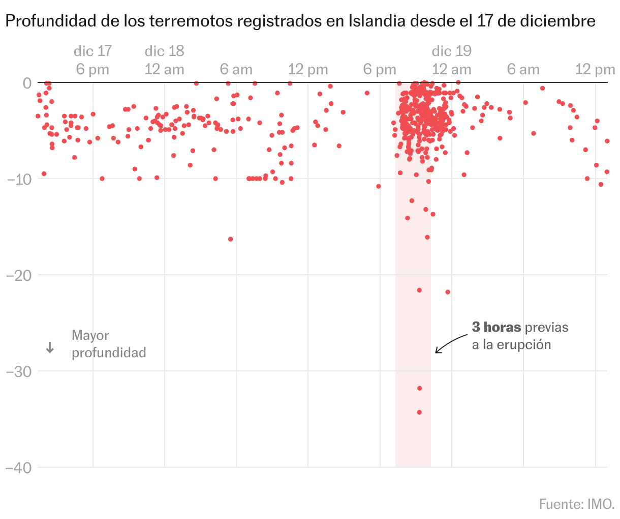
In the three hours before the eruption, data from the United Nations International Maritime Organization indicates that at least 258 earthquakes were recorded. In the previous 24 hours, there were at least 450.
But the authorities were already on alert and last month had evicted the almost 4,000 inhabitants of Grindavik (closed the nearby Blue Lagoon resort spa). They knew that an eruption was probable due to the seismic movement that had been recorded for almost two months.
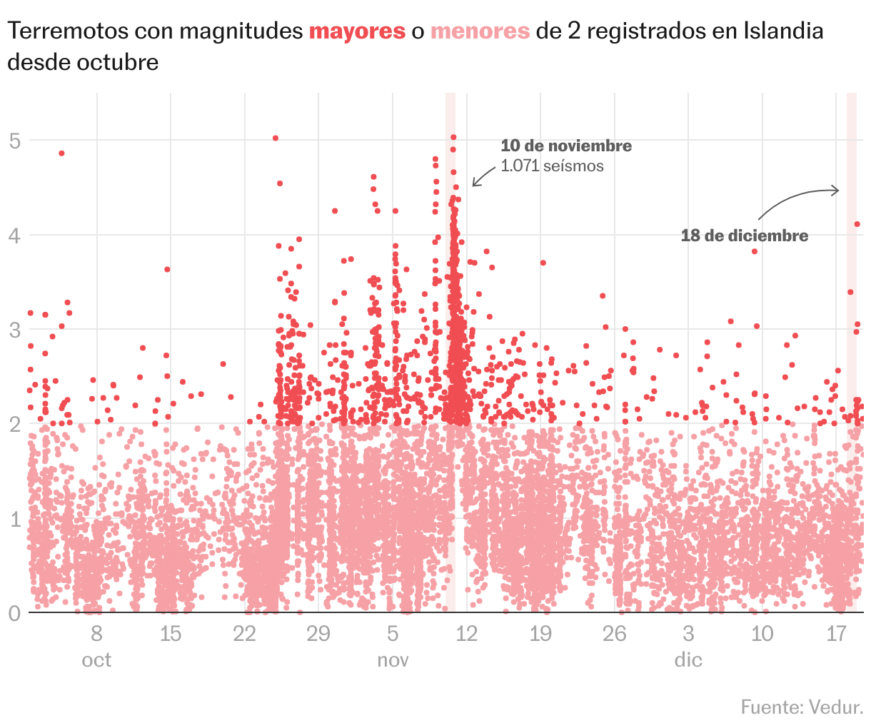
The earth shook much more than this Tuesday on several days in the last month: between November 10 and 11, at least 1,071 earthquakes had been recorded, for example. Why was there no eruption then? “We will not know until after some time, when scientists have collected all the data and can study it in detail,” argues Méndez Chazarra. “In addition, although the system seemed calm, the deformation continued and seismic swarms still occurred, which caused the authorities to decide to maintain the alert level in certain areas due to the possibility of an eruption.”
A key factor in monitoring earthquakes is the depth at which they occur. “It tells us where the magma is moving and where it could be accumulating, as well as the area where it would have the most chance of breaking on the surface,” explains Méndez Chazarra. In the two hours before Tuesday's eruption, half a dozen shaking were recorded in the hundred meters closest to the surface.
A good sign is that this eruption produced in the southwest of Iceland has entered a state of equilibrium just a few hours after it began. It would have been more dangerous if it had occurred further north, in the frozen areas of the island (there is hardly any ice in the south). That was where, in 2010, the Eyjafjallajökull volcano paralyzed European air traffic: it was another type of eruption, not effusive but explosive, in which the lava coming out of the volcano can be transformed into volcanic ash that, in large quantities and distributed throughout the atmosphere, can cause airspace closure.
The Icelandic authorities maintain that the intensity of the event began to decrease four hours after it began: except for when it was going to occur, most of the parameters of the eruption are as expected. Of course: it is possible that new magma exit points will open along the original fissure, warns the Iceland Meteorological Institute.
You can follow SUBJECT in Facebook, x and instagramor sign up here to receive our weekly newsletter.
Subscribe to continue reading
Read without limits
_
#Data #hundreds #earthquakes #explain #eruption #southwest #Iceland