EL PAÍS offers the América Futura section openly for its daily and global information contribution on sustainable development. If you want to support our journalism, subscribe here.
“Uruguay is not a river, it is a blue sky that travels.” This is how the late Uruguayan poet and singer Aníbal Sampayo described the Uruguay River in his 1963 song. River of Birds, a tribute to the current that passes through his hometown, Paysandú. His verses are a kind of sound photography: they preserve local characters, flora and fauna, and moments of river life. But they do not talk about the bad luck that the Uruguay River sometimes brings to those who live there.
Four years before Sampayo released River of Birdsthe largest occurred flood that is remembered. It equally affected the banks of Argentina and Uruguay, which share the final stretch of the river before its confluence with the estuary of the Río de la Plata. Six decades later, Paysandú and other cities along the lower course of the Uruguay River face a similar, perhaps worse, threat: increase of precipitation, a trend that, according to forecasts, it will intensify.
In the Argentine province of Entre Ríos, whose eastern border is formed by the Uruguay River, average annual rainfall increased 20% between 1960 and 2010. In Uruguay, it is estimated that these increased between 10% and 20% between 1961 and 2017. The heaviest rainfall during that period was recorded in the southeastern and southwestern regions of Uruguay, the latter including cities along the Uruguay River.
“The climate in Uruguay has tropicalized at a very rapid pace in recent decades,” says Gustavo Olveyra, coastal adaptation specialist at the United Nations Development Program (UNDP) in the country. “It rains more and worse because there are more days with extreme phenomena; the frequency and intensity of the winds have increased; the number of very hot days and the duration of droughts.”
Patricia La Nasa, a specialist in environmental conflicts and risk control in Argentina, agrees: “We are seeing changes in seasonality and in the amount of average and torrential rains per year.” But not only the climate has affected the river and the life that surrounds it. Some riverside cities have seen their urban area grow to 200% in the last 20 years, while forest fires and deforestation – especially in the north, in the southeast Brazil, where the Uruguay River is born—have become part of the landscape. Other factors have also taken their toll: the expansion of livestock farming and forestry industries on both shores, the degradation of wetlands and changes in land use that prevent the absorption of flood water.
The flow of the Uruguay River has also been permanently complicated by the dam of Leap Large, located between Argentina and Uruguay. Inaugurated in 1979, it has a reservoir that covers almost 800 square kilometers (almost double the area of Barbados) with a concrete and earth wall 2,500 meters long. “The Uruguay should be a stable river,” says NASA, “but the dam radically changed its downstream dynamics. “It modified the flow speeds, the way it settled and the degradation processes of the coastal edges.”
Displacements
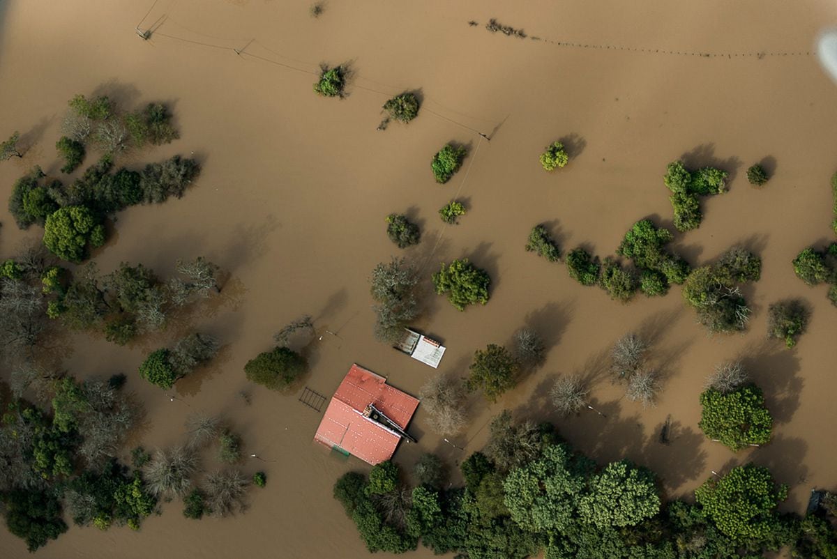
In September, torrential rains in southeastern Brazil overflowed the Salto Grande dam, forcing more water than usual to be released into the Uruguay River downstream for several months. Added to this were local rainfall above average. As a result, all cities on both sides of the river suffered varying degrees of flooding from mid-October to early January: Concordia, Concepción del Uruguay, Colón and Gualeguaychú, in Argentina; Bella Unión, Salto, Paysandú, San Javier, Nuevo Berlin and Fray Bentos, in Uruguay.
More of 3,000 people They were forced to abandon their homes in Paysandú, as well as about 500 families in Concordia. In recent years, authorities in both cities have made efforts to relocate residents of flood zones to safer neighborhoods.
This measure of displacing inhabitants of lowlands or inland basins – who also generally have limited economic means – has been implemented by the most affected municipalities, but has been controversial. Alejandra Puglia, a teacher and member of the environmental organization Friends of the Fray Bentos Wetlands, maintains that many families do not want to be displaced: “They have a strong sense of belonging, and they lack alternatives or opportunities to change their way of life if they are relocated. somewhere else in the city.”
Adaptation in the Uruguay River
In 2015, this accumulation of problems prompted the UN Climate Change Adaptation Fund to finance a project in the lower reaches of the river, downstream of the Salto Grande dam. The result is the Uruguay River Climate Action Plan, lasting four years and executed by UNDP between 2021 and 2025. The project has a budget of 14 million dollars to finance works and activities distributed equally among 12 towns and cities on both banks of the river, representing approximately 650,000 people in total.
The latest floods reinforced the idea that this adaptation is essential. “This time was not the worst, the biggest problem was that it lasted too long,” says Natalia García, coordinator of the Río Uruguay Climate Action Plan.
The first and most advanced step of this project is the training of citizens and officials on the effects of climate change, so that this perspective can be incorporated into urban planning codes. “People need to know what to do when early warning systems warn them that a storm with strong winds is approaching,” says UNDP's Olveyra, who works as an adaptation specialist for the project. “Do we shelter them in safe places, away from the windows, or do we send them home with the risk that the storm will find them waiting for the bus?”
The creation of “flood parks” or coastal walks is common in almost all participating cities. “These are areas that have generally been left free after the relocation of residents,” explains García. “The objective of the parks is to prevent them from being reoccupied by informal settlements, which reduces risks, and at the same time revalue the ecosystem services that nature provides in the floodplain.”
To date, only inaugurated La Esmeralda park, in Fray Bentos. The rest are still in the pre-approval phase or under construction. In Fray Bentos and Nuevo Berlin, both located in the Uruguayan department of Río Negro, the recovery of native flora in parks and streets has become an area of interest. Diálogo Chino spoke with the director of Environment, Hygiene and Bromatology of Rio Negro, Adrián Stagi: “We have designed a park along the Los Laureles stream that we will reforest with native species of trees and flowers. And we want to do the same with the city's urban trees.”
Another objective of the adaptation plan is to reduce or stop the serious consequences of riverbank erosion. It is one of the main consequences of the daily management of the dam's water. “When Buenos Aires turns on the lights, Salto Grande needs to produce more energy and opens the floodgates,” explains NASA, which oversees the Argentine elements of the project's social and environmental safeguards. “This causes pronounced changes in river level in a matter of hours and accelerates the erosion of banks, beaches and coastlines.”
In Concordia (Argentina), river bank erosion is causing debris to accumulate at catchment points used by the city's water treatment plant, posing a threat to the quality and safety of drinking water. To combat this situation, one of the largest initiatives to defend the river banks of Argentina has been proposed, in order to consolidate the eroded areas. Similar works are being planned upriver, in Argentina's El Palmar National Park, and along a road to Rincón de Franquía, a protected area in the northwest corner of Uruguay.
Next steps
The completion of the Uruguay River Climate Action Plan is scheduled for 2025. Some of those responsible admit that this period is not enough to solve all the existing problems in the river. “The virtue is to focus on these issues and raise awareness among the population and the authorities,” says NASA. “Afterwards, each aspect will have to be managed constantly and intensively for a long time.”
Awareness among riverside municipalities appears to have improved, and adaptation ideas driven by the project are emerging. For example, Concordia will soon inaugurate a water purification plant, Fray Bentos is working on a composting plant and Río Negro on an effluent treatment plant. Uruguay, for its part, wants to modernize its early warning capacity, moving from a regional mosaic to a national multiple-threat warning system.
For now, the riverside residents are waiting to see if they are fulfilled the forecasts of new above-average rains fueled by the climatic phenomenon The boy. Meanwhile, the Uruguay River continues its course. It's not always the journey of blue skies and bucolic charm that Aníbal Sampayo sang about, but with the support of the climate adaptation project, there could be positive change in the future, and benefits for more than half a million people who live along from the banks of the river.
#Uruguay #Argentina #adapt #rising #rivers