Wednesday, May 3, 2023, 01:31
Spain ended the winter with a long-lasting drought and March ended as the second warmest and with the least rain this century, according to the State Meteorological Agency (Aemet). With reserves and temperatures experiencing an unusual escalation for a month of April, everything points to a worsening of the long-term meteorological drought that began in the Iberian Peninsula at the end of 2022.
The latest report from the EU’s Copernicus Climate Service revealed a few days ago that temperatures in Europe rose twice the global average last year. Along with a drop in rainfall, this caused the drought to spread across the continent, registering the second lowest humidity indices in the last fifty years and a decrease in flow in 63% of European rivers. This situation has triggered alarms, which has increased surveillance and monitoring tasks throughout the continent with different methods of droughts, which are classified into different types depending on their nature and effects.
Scroll down to start chart
Flash droughts are different from traditional meteorological ones, which affect large territories and occur progressively. Rather, these flash droughts are characterized by rapid development and intensification, making early warning and monitoring difficult. They can appear and reach their peak in a matter of days or weeks. The scarcity of rain is an essential element, but the trigger occurs when the atmosphere, due to a heat wave or the appearance of dry winds, demands and does not obtain the humidity that under normal conditions evaporates from the soil and the plants sweat. This exchange of humidity between the atmosphere and the vegetation on the ground is broken, producing a fast and intense drought.
Scientists from the Pyrenean Institute of Ecology, attached to the CSIC, have developed an almost real-time monitoring system for sudden droughts throughout Spain, based on the so-called Standardized Precipitation and Evapotranspiration Index (SPEI). How does the system work? Daily meteorological data (precipitation, maximum and minimum air temperature, relative humidity, duration of sunshine and wind speed) are recorded from the Aemet network of meteorological stations. These data are quality controlled, aggregated weekly, and interpolated to obtain gridded data sets for each meteorological variable, which are used to calculate the Standardized Precipitation Evapotranspiration Index (SPEI). The system offers information on drought conditions with a high resolution (1.1 km by 1.1 km) and temporal frequency (weekly). Thanks to this system, the Spanish scientists from the CSIC have been able to analyze the sudden droughts that appeared from 1961 to the present day.
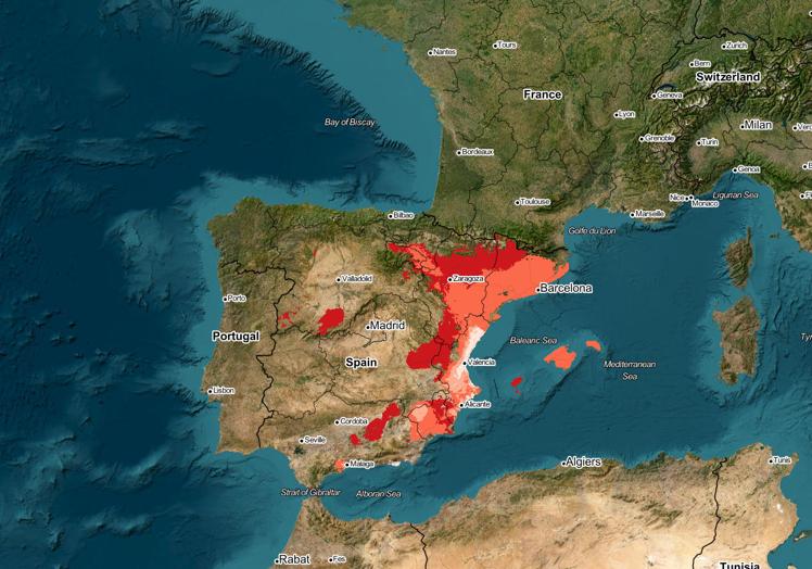
Flash drought monitor. It measures the evolution of the Precipitation Evapotranspiration Index (SPEI) in periods of four weeks. Red marks the territory where the SPEI has just gone below a critical threshold; orange indicates the territory that shows that value for one week: pink shows the area that has had that SPEI for two weeks and white the area with the aforementioned critical value for three weeks.
CSIC
CSIC scientists have verified that these sudden droughts are more frequent in the wetter territories of the Iberian Peninsula, mainly in Galicia and other areas in the northwest. In recent years, multiple studies have appeared that point to a greater frequency of this type of devastating drought throughout the planet due to climate change.
The CSIC and the Aemet collaborate in the use of this meteorological drought monitor that allows real-time information to be obtained on the conditions in each point of the territory, which makes it possible to determine if they are attenuating or, on the contrary, worsening. This information is key to be able to anticipate measures that help forecast and in some cases mitigate the effects on crops, grazing areas, rivers and reservoirs.
#droughts #monitored


