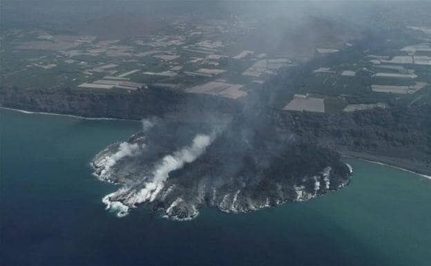
The new land reclaimed from the sea by the lava flows from the Cumbre Vieja volcano. /
The eruptions in the Canary Islands have contributed to the country almost 20 extra square kilometers in the last 600 years
Spain officially measures 506,030 square kilometers. It is a round figure, without a comma to the right. But it cannot be ruled out that within a few weeks, when the Cumbre Vieja volcano decides to put out its fire and stops expelling lava into the sea, it will have grown another kilometer. As you read these lines, our country continues to expand centimeter by centimeter as the lava platform gains ground from the Atlantic Ocean due to the contribution of runoff. In the three weeks of the eruption, La Palma, the archipelago and Spain have grown by almost 40 hectares, a little less than half a square kilometer. The San Juan eruption in 1949, on the same island, made the territory grow by four square kilometers. And that of Teneguía, just 50 years ago, in another two kilometers. That volcanic origin of the Canary Islands (the base of the islands is a million years old) is the one that expands its territory like nowhere else in Spain. In fact, according to the Canarian geographer Cayetano Guillén, the archipelago has extended its surface in 19 square kilometers, all gained from the sea, by the different eruptions of the last five centuries.
The first documented eruption occurred at Montaña Quemada, very close to the current one at Cumbre Vieja. Although the chronicles do not specify a date, it is between 1430 and 1440. Throughout these 600 years there have been 17 eruptions (8 on La Palma) and almost all have ended at sea, which has expanded the coastline in almost twenty square kilometers.
The rivers of solidified lava that these days descend the slopes to the ocean will gradually increase the surface of La Palma, forming the newest land in Spain. Until where? “For now we know that the lava delta that is generating the Cumbre Vieja eruption has generated an area increase of about 40 hectares. But it is a temporary photo. There is no forecast that it will end in the short term and in the Canary Islands there are magnificent examples of much larger lava platforms, such as the one generated by the San Juan eruption ”, says this professor of Geography at the University of La Laguna, in Tenerife, and member of the Professional College of Geographers.
What the sea gains will have consequences when it comes to setting the exact measurements of the surface of our country, something on which, by the way, nobody seems to agree. Geographers, for example, usually take the figure of 505,989.8 square kilometers as good (they round it up to 505,990), in line with what the National Institute of Statistics indicates. The United Nations places it at 505,957, while the Ministry of the Environment, in 2005, reduces it to 504,645. Although the official figure is the one managed by the Presidency of the Government, which sets it at 506,030 square kilometers (40 more than the first). This swaying of numbers contrasts with the accuracy expected of a science that studies the physical patterns of the Earth. Or maybe not so much. “We have to know that the Earth has its own times and its own rhythms and we are used to measuring times on a human scale. And the whole of the territory of our country is subject to constant changes, especially in coastal environments. The coastlines of the Iberian Peninsula are very dynamic. There are areas where territory is destroyed, on cliffs, and other areas where the peninsular territory grows, such as the deltas of the great rivers. Sedimentary material accumulates there and this causes the surface to increase or decrease depending on the tides “, illustrates Guillén, for whom the point of those 505,989.8 kilometers could be altered” every year “and even more so in volcanic territories, like the Canary Islands, “where a volcano is capable of generating drastic changes over the territory on a human time scale.”
In real time
As a canary, Guillén feels the terrible consequences of the Cumbre Vieja eruption in the palm trees and its economy (“there is a very emotional part that you cannot dissociate”), but as a geographer he knows that we are witnessing an extraordinary process by being able to see in time real changes “that we would not see in other morphodynamic contexts.” “This suddenly gaining forty hectares from the sea, either you see it in volcanism or you don’t see it,” he says. “Seeing in real time and at a scale that you can manage how new territories, new landforms and new forms are created is really exciting for a geographer. It is as if you see live how a part of the Earth was created ».
Guillén, however, does not believe that the growth of the fajana or lava delta reaches the dimensions of that of San Juan. “It will surely be less, although the two platforms will eventually come together. It must be taken into account that from 500 meters of coast, there are abysses that reach 4,000 meters of depth “.
.


