The land reclaimed from the sea by lava, similar in size to Vatican City, and the land surface that has washed away the lava will be visible in the new planes. The most urgent thing is to modify the nautical charts to avoid maritime accidents
Checking in this comparator the surface of famous constructions with the size of the lava delta (image of October 6) can give an idea of its true dimension. The lava has reclaimed 40 hectares from the sea, an area slightly less than that of Vatican City, but which would fit the square and St. Peter’s Basilica.
The eruption of the Cumbre Vieja volcano will force the maps to be redrawn. The lava that has flowed into the ocean has modified the coastline of the island of La Palma by creating a lava delta of about 40 hectares, a territory that would fit the Egyptian pyramid of Cheops or the Brazilian stadium of Maracana. But in addition to the land reclaimed from the sea, the wash has swallowed up any construction and infrastructure built along the more than 430 hectares through which it slides. And this devastated terrestrial space is not minor. In it, the Forbidden City in Beijing could be built four times and the New York park of Central Park would fit. This search engine allows you to superimpose the surface devastated by the volcano anywhere in the world:
“It will be necessary to update the cartography of La Palma, which is covered by lava, where the landscape has obviously changed, buildings, communication routes and infrastructures have disappeared”, explains Marcos Pavo López, head of the area of the Central Registry of Cartography of the National Geographic Institute (IGN). “That area”, he continues, “will have to be represented on a land use map as a volcanic area.” Although what is today a territory devastated by lava, in the future it may be something very different. The Timanfaya National Park, in Lanzarote, is, for example, the result of different volcanic eruptions – one of them, in 1730, lasted six years.
But the plans will need more modifications because the surface reclaimed from the sea by the lava is large enough to be perceptible on maps with a certain definition. According to Pavo López, “the size of the area that has been created new right now would be quite imperceptible on small scales, but on a scale of 1: 25,000 [en un centímetro en el mapa se representan 25.000 centímetros de la realidad] or at 1: 50,000, which are the scales up to which the IGN works, it would be noticeable ”.
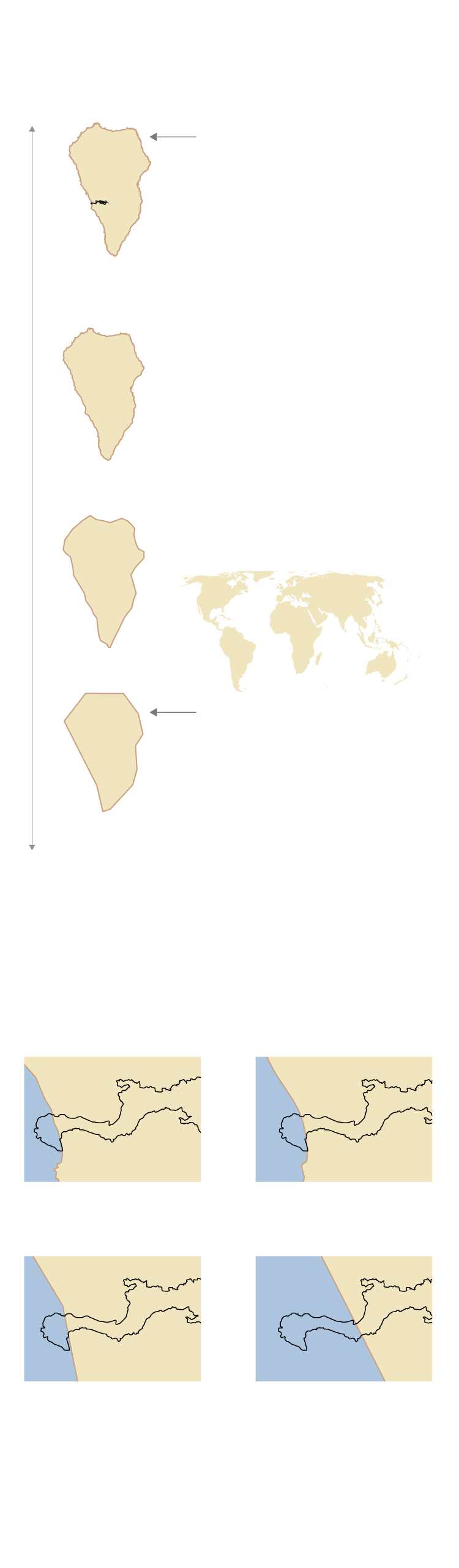
Maps are designed at different levels of detail, or scale, depending on how they will be used.
Smaller-scale maps are designed in more detail and can be enlarged without losing precision.
To see the whole world you do not need that level of precision and larger scales are used.
The eruption of the La Palma volcano will force to redraw only maps from a certain scale: where you can see a sufficient level of detail.
In addition, all maps showing roads and infrastructure destroyed by lava will have to be modified.
Source: IGN and Natural Earth.
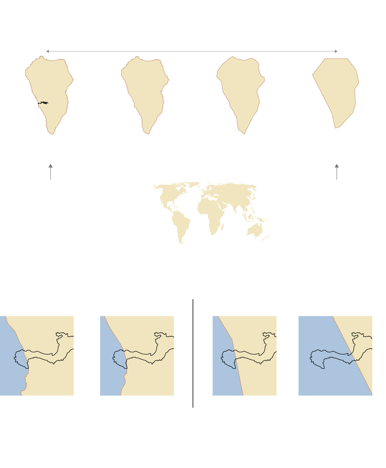
Maps are designed at different levels of detail, or scale, depending on how they will be used.
To see the whole world you do not need that level of precision and larger scales are used.
Smaller-scale maps are designed in more detail and can be enlarged without losing precision.
The eruption of the La Palma volcano will force to redraw only maps from a certain scale: where you can see a sufficient level of detail.
In addition, all maps showing roads and infrastructure destroyed by lava will have to be modified.
Source: IGN and Natural Earth.
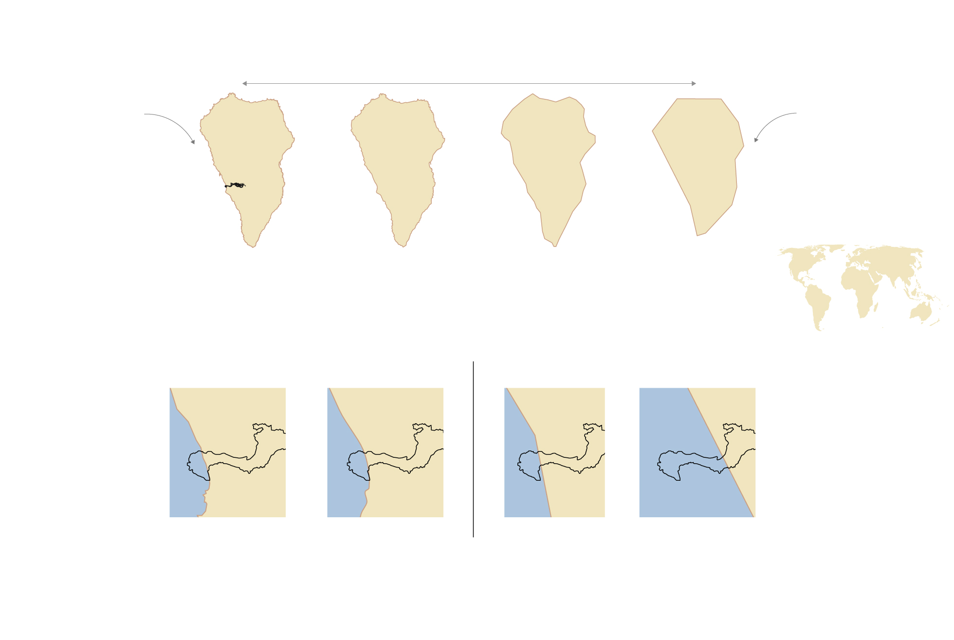
Maps are designed at different levels of detail, or scale, depending on how they will be used.
To see the whole world you do not need that level of precision and larger scales are used.
Smaller-scale maps are designed in more detail and can be enlarged without losing precision.
The eruption of the La Palma volcano will force to redraw only maps from a certain scale: where you can see a sufficient level of detail.
In addition, all maps showing roads and infrastructure destroyed by lava will have to be modified.
Source: IGN and Natural Earth.
It is not clear when the small lava delta, still unconsolidated, will be incorporated into the new maps. “Right now we are working on cartography through photogrammetric flights, with which digital photographs are taken, with a periodicity of between two or three years,” says the IGN expert, who recalls that the first Spanish topographic map took almost a long time to complete. 100 years. “The first sheet, from Madrid, was made in 1875, and it was in 1968 when the entire territory was covered” with the publication of the sheet of San Nicolás de Tolentino, on the island of Gran Canaria. “Of course, from the seventies the speed grew exponentially thanks, precisely, to the use of photogrammetry”, he points out.
Although beyond the terrestrial maps, the truly urgent thing is to modify the nautical charts, responsibility of the Hydrographic Institute of the Navy. “Here there is a more difficult problem, what emerges on the surface of the sea can be seen and is not problematic, but the lava flow that has fallen into the ocean has changed the depth and that is not seen,” warns Pavo López. Hence the urgency of redrawing the nautical charts, which not only reflect the shape of the coast but “the obstacles and depths in the worst case, that is, when it is at low tide.” “A boat with a certain draft must know how far it is to an obstacle or to the bottom when the tide is lower,” he adds. And although the new edition of the letter takes a long time to be published, the current ones, both digitally and on paper, will have a “notice to sailors” —on printed ones a sticker is usually used — to warn of new obstacles.
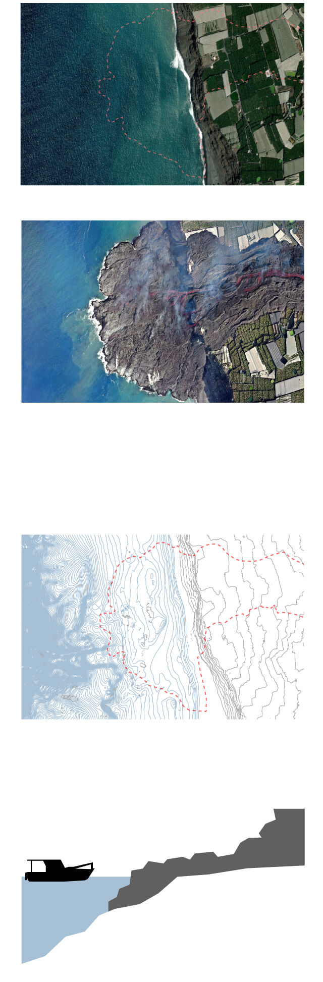
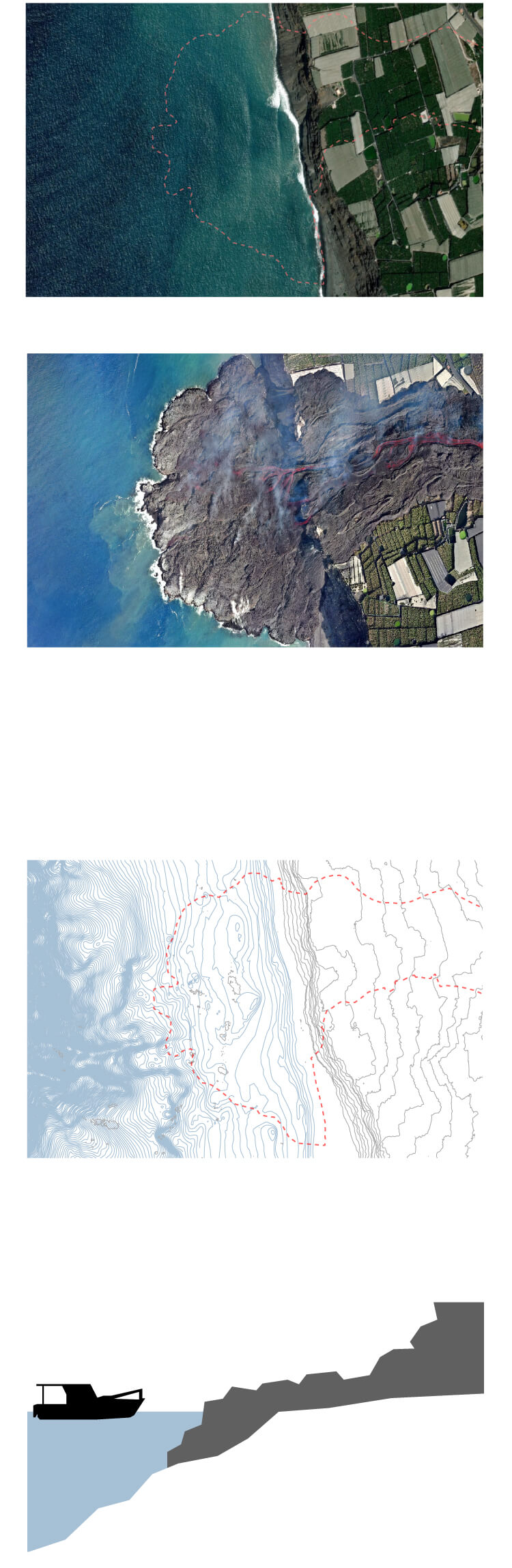
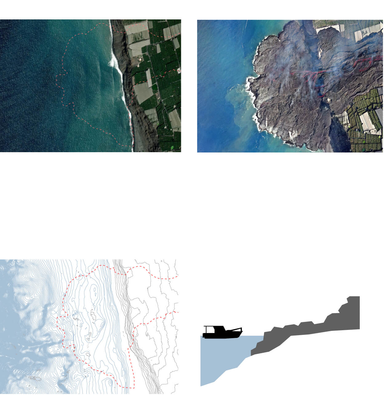
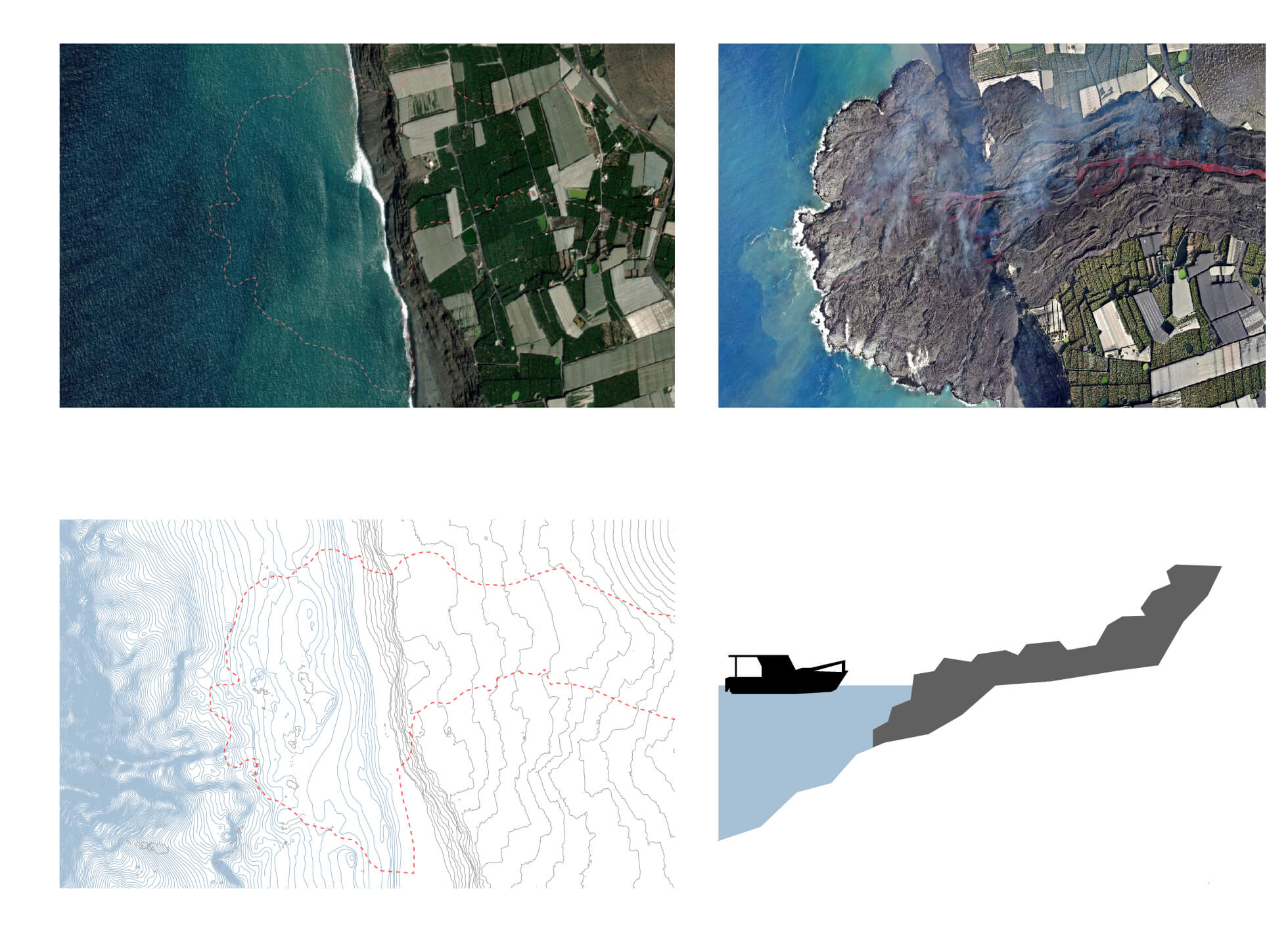
Drone image of the Cabildo Insular de La Palma
from October 6
The eruption has modified the ocean floor and with it the depth data reflected on nautical charts like this one.
Ships will need new exact sea depth data to navigate and to approach shore.
Drone image of the Cabildo Insular de La Palma
from October 6
The eruption has modified the ocean floor and with it the depth data reflected on nautical charts like this one.
Ships will need new exact sea depth data to navigate and to approach shore.
Drone image of the Island Council
from La Palma on October 6
Ships will need new exact sea depth data to navigate and to approach shore.
The eruption has modified the ocean floor and with it the depth data reflected on nautical charts like this one.
Ships will need new exact sea depth data to navigate and to approach shore.
The eruption has modified the ocean floor and with it the data
deep reflecting nautical charts like this one.
The satellite image is from ESRI (left) and the one from a drone from the Cabildo Insular de La Palma (6 October).
More changes
The alteration of maps and nautical charts is not the only consequence of the increase in territory. “The official surface of both the municipality of Tazacorte and the island of La Palma will have changed,” explains Marcos Pavo López. The IGN will have to issue a “new certification” of this new size, a document that Pavo López himself must sign and that is used, among other purposes, “for the distribution of some subsidies or certain aids that are in proportion to the surface ”.
And although the maritime borders are not delimited with a real line, the limits of the territorial sea, which extends along 12 nautical miles from the coastline, and of the exclusive economic zone, over which Spain exercises rights, will also change. special exploitation and use of marine resources and that extends from the base of the coast up to 200 nautical miles into the ocean.
You can follow MATTER in Facebook, Twitter and Instagram, or sign up here to receive our weekly newsletter.
More information
/cloudfront-eu-central-1.images.arcpublishing.com/prisa/ENQG2NYFBVFKNH4CQPIWLKIVJA.jpg)
/cloudfront-eu-central-1.images.arcpublishing.com/prisa/KAOVL5LYOJHUHDIYZYPXGUDSJY.jpg)


