Florida could begin to feel Ian’s wrath as early as Tuesday, with hurricane conditions potentially hitting the state on Wednesday. (Credit: Reproduction)
Hurricane Ian continues to get stronger as it approaches Florida, prompting urgent evacuations and threatening dangerous storm surges in places not used to being hit directly by a hurricane.
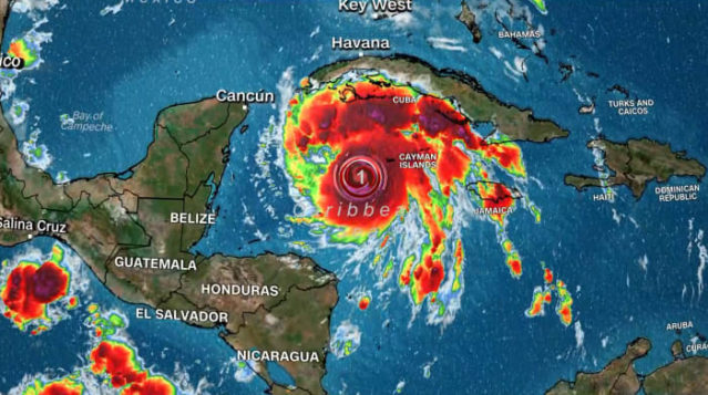
Ian is now a Category 2 hurricane on the Saffir-Simpson wind scale, according to an update from the Miami-based National Hurricane Center. The eye of the storm is located about 240 kilometers southeast of Cuba’s western tip and Ian is moving north-northwest at about 20 km/h, the center said.
+ Florida braces as Hurricane Ian approaches the coast
Florida could begin to feel Ian’s wrath as early as Tuesday, with hurricane conditions potentially hitting the state on Wednesday.
The hurricane center’s forecast for Ian “showed an unprecedented rate of strengthening from a tropical storm to a powerful hurricane,” a local meteorologist said.
Ian’s winds intensified from 136 km/h on Monday afternoon to 160 km/h in the late afternoon. Meteorologists expect Ian to become a major hurricane before hitting the US, with winds reaching 178 km/h or more.
Conditions in western Cuba are expected to worsen overnight, with “significant impacts from winds and storms expected,” the hurricane center said. Ian will likely be Category 3 with winds of 120 mph or more when it moves over Cuba on Tuesday morning, forecasters say, and is also expected to produce flash floods and possible landslides in parts of Jamaica and Cuba.
A total of 19,283 people were evacuated from their homes in the province of Pinar del Río, in western Cuba, according to state channel TelePinar.
“The storm surge could raise water levels up to 2.5 to 4.5 meters above normal tidal levels along the west coast of Cuba in areas of land winds in the hurricane warning area tonight and Tuesday. fair,” said the center.
In the US, more than 15 million people are expected to experience at least tropical storm-force winds in cities like Tampa, Orlando, Tallahassee and Jacksonville, Miller said.
A storm surge warning has been added for parts of western Florida with a potential 1.5 to 3 meters of tide, according to the latest statement. The “life-threatening flood” warning extends from the Anclote River south to Flamingo and includes Tampa Bay.
The hurricane watch from Englewood to the Anclote River, including Tampa Bay, has been updated to a hurricane watch, according to the latest Hurricane Center statement. That means “hurricane conditions are expected somewhere within the alert area, in this case, within 24 to 36 hours,” the center said.
#Hurricane #Ian #havent #lifetime