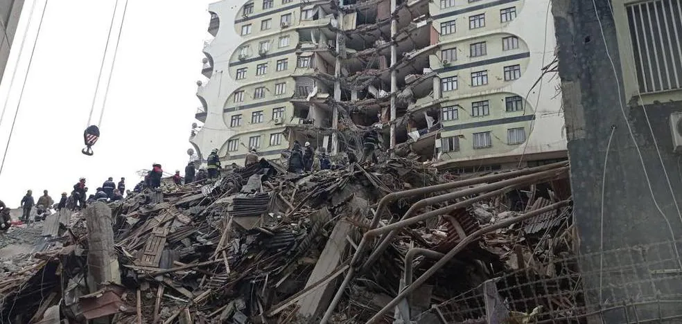
Some buildings affected by the earthquake on Monday in Turkey and Syria have been left standing but with serious damage /
Turkey sits for the most part on the Anatolian plate and its map is crossed by several faults, a “complex” situation that increases the risk of earthquakes

It had been more than eight decades since Turkey had endured an earthquake as serious as the one that occurred at dawn on Monday, and which has also affected neighboring Syria, but the truth is that the area where the earth trembled appears between the points on the map susceptible to this type of phenomenon. Most of the country falls on the Anatolian plate, trapped between others that can exert pressure from various fronts and, as a consequence, cause large earthquakes. But the intensity of the last one, 7.4 on the Richter scale with aftershocks of up to 7.8, has been “outrageous,” admits Arancha Izquierdo from the National Seismic Network.
Turkey, due to its geographical position, is marked as an area of high seismic activity and only in 2022 it recorded more than 20,000 earthquakes, although far from the “enormous” magnitude of the last one. Of course, among them there were more than a hundred that exceeded level 4 and one passed level 6. In fact, last autumn a drill was organized at the national level -it was carried out simultaneously in 81 provinces- that has not been able to avoid the This Monday’s disaster in the south of the country, with its epicenter in the province of Kahramanmaras, whose force has even made Greenland tremble, as the Danish geological institute has detected. The intensity has been such that the tsunami alert has even been activated in Spain and Italy, although it has been canceled in a short space of time.
The risk that Turkey will tremble, and above all that it will do so violently, derives from the fact that the Anatolian plate on which the country is based is located, in turn, between two large platforms (the Eurasian and the African). and a smaller one (the Arabian). The result is that several faults – a kind of fracture of the terrain – run through its map and one of the most dangerous, where the Turkish and Eurasian plates coincide, passes very close to Istanbul. On this occasion, the origin of the earthquake occurred in one located in eastern Anatolia -towards the border with Syria- although “globally the area is very complex and has a high seismicity”, emphasizes the seismologist.
The earthquake this Monday in Turkey and Syria – the worst since 1939, then with about 33,000 deaths and some 100,000 injured – has caused an area of ”about 200 kilometers to move”, calculates Izquierdo, and the risk now is that the aftershocks will cause even greater damage. Only eleven minutes after the earthquake, a reading of 6.7 on the Richter scale was registered and less than twelve hours later, another of 7.5. The seismologist warns that “the possibility of there being more is great” and assumes that it will take several days to guarantee that there are no more tremors. “The problem is that the buildings that have remained standing are already very vulnerable,” she portrays.
The Turks live with the risk of earthquakes in such a way that in homes and workplaces there are safer areas in the event of an earthquake and even the authorities are involved to minimize the consequences of these phenomena. Without going any further, last fall, the country organized a nationwide drill that was carried out simultaneously in 81 provinces. But, when the earth shakes for real, there is no one who can stop its force.
#area #high #risk #seismic #movements


/cloudfront-eu-central-1.images.arcpublishing.com/prisa/T732SJQ2XQRMR7CQ2BFTHI3LNA.jpg)


/s3/static.nrc.nl/images/gn4/stripped/data97711597-20cfdd.jpg)
