The mountain as a refuge, as recreation, as a theater of dreams, as a disconnection, as a playing field… everyone has an explanation at hand for plunging into the natural environment. And the number of those interested in finding, why not, knowledge grows: scholars of the fauna and flora, of the history of its inhabitants and of the architecture of those mountains that take your breath away.
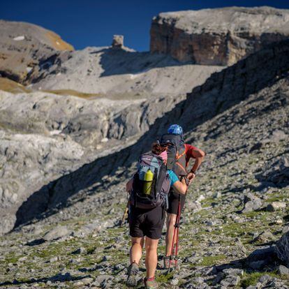
In the Pyrenees, one of the most impressive routes that can be done has had a name for a few years: the High Route of the Lost, a circular journey on horseback between the north and south of the chain, in the middle of the Vignemale and Monte Perdido massifs. This route jumps from one refuge to another, from Bujaruelo to Oulettes de Gaube, passing through Goriz, Pineta, Espuguettes and the Grange de Holle until adding 93.5 kilometers and 6,532 positive meters of unevenness that are covered along One week. So it requires good physical shape and experience in similar routes.
The mountaineer Alberto Iñurrategi is one of the guides who is a fan of this route and who convinced the geologist Asier Hilario to offer added value to the high route by explaining the secrets of the unique landscapes that the trip offers. Although expert of flysch from Zumaia, Hilario completed his doctoral thesis in Benasque and his main motivation has to do with mountain geology and, especially, the Pyrenees. “I can’t think of a more suitable route in the Pyrenees to explain the history of this chain and understand the architecture of these mountains. And the thing is that the route runs through two massifs, Monte Perdido and Vignemale, and each of them represents the two Pyrenees very well: I say there are two because it is a chain that hides another inside. It is as if they were two chains in one”, he explains.
The first, according to the expert, is very old, it originated about 300 million years ago, when all the continents collided to give rise to Pangea (the so-called supercontinent, a unique one formed 300 million years ago when all the continents collided). and, from that powerful shock, many rocks melted and that gave rise to these magmas, when they cooled, creating granitic rock. “That old chain can be seen in the central or axial Pyrenees (for example, Maladeta, Posets, Perdiguero… or the Panticosa area). This area is flanked to the north and south by the most recent Pyrenees, because that enormous chain created 300 million years ago eroded and the continents that collided to create Pangea separated again to give rise to something similar to the continents we know today. ”, adds Iñurrategi. In this separation of continents, the sea flooded the sediments of the eroded mountain range on which enormous amounts of limestone were deposited. Later, when the Iberian plate collided with Europe, everything collided and rose to form the current Pyrenees. “And those huge limestones, deposited between 150 and 50 million years ago, are today the Monte Perdido massif. It is a route that shows very well the geological history of the Pyrenees”, sums up Hilario.
Bulletin
The best recommendations for travel, every week in your inbox
RECEIVE THEM
Clients who hire the route have Iñurrategi, the youngest man to climb Everest without artificial oxygen (at the age of 23), sixth to add the 14 eight thousand of the planet, a sports reference with an interesting historical perspective of the mountaineering activity. During the breaks, and in certain places especially chosen by Asier Hilario, the geologist brings his gaze: “On the road what I want is for people to understand that when looking at a mountain nothing is there by chance. All the shapes and colors respond to a certain type of rock, to a specific structure. Mountains are like buildings: you need some materials (rocks), and that these have a more or less complex architecture and you also need that they have a good façade to give rise to valleys, glaciers, rivers and walls. With what they learn on this route, those who share the path with us can understand mountains from anywhere else. I give them keys to look at, ”he details. In addition, he has a perfect analogy to explain what we lose when we move forward without knowing what we observe: “Walking through the Pyrenees without the intention of understanding the mountains is like walking through the Prado Museum blindfolded.” We value Van Gogh much more since we understood his madness.
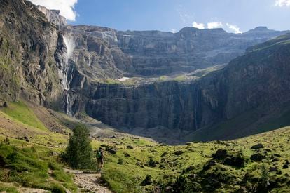
Monte Perdido, that peak that was intuited and no one was right to find, is, in Hilario’s opinion, “a monument of geology.” The summit is not only one of the most desired by hikers each summer, but also a perfect model to understand many unknowns. “With El Perdido you can see very well how the mountains grow and take on relief: how some limestone formed under the sea 50 million years ago today reaches 3,400 meters in height. You can see how these large limestone packages, originally horizontal, are placed over and over again one on top of the other until they create a mountain”, he illustrates. It is also an exceptional enclave to understand geomorphology: how the relief we see today has been formed, from the Pineta valley to the Añisclo canyon or the Ordesa valley. “40 million years ago, a glacier descended through the Ordesa Valley that had 300-400 meters of ice thickness and 70 kilometers in length, and the same in Pineta. “It was like Karakorum is today,” illustrates the expert.
At the end of each day, after settling in the shelter, Asier Hilario offers a meeting to recall what has been seen and further explanations. “In the geological interpretation of mountains, what is seen is just as important as what is not seen.” Just as in the Alps the rapid disappearance of its glaciers and deep ice caused by climate change offer an image of a sick mountain, in the Pyrenees wear escapes uninitiated eyes. “A different future awaits the Pyrenees, neither better nor worse. A future without glaciers (in 30 years they won’t be left), with less snow, with a summer that will start earlier and end later, where there will be less water… it will look like Gredos but like a beast”, sums up Hilario.
Technical sheet of the High Route of the Lost
- Circular route starting and ending at the Bujaruelo refuge.
- Six stages, seven days.
- 93.6 kilometers; 6,532 positive meters; 6,509 negative meters.
- Preferred time: from June to the end of September.
- Required level: good physical condition and experience in similar routes
- Price per person: 975.55 euros. Nights in guarded refuge with breakfast and dinner.
- More information and reservations: laaltaruta.com/alta-ruta-geologica
Subscribe here to newsletter of The Traveler and find inspiration for your next trips in our accounts Facebook, Twitter and instagram.
#Walking #Pyrenees #desire #understand #mountains #visiting #Prado #Museum #blindfolded


